Section Preview
Shows a schematic cross section of the trench at the station
specific.
This profile can help you make decisions about imposing elevations in the pipes,
since it can show the projection of all the pipes which arrive in a box.
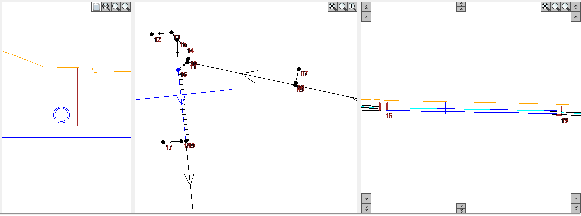
Note: the "ticks" in the plant.
They indicate the sections that were sampled for the section.
The distance between them is defined by the distance between sections in
parameters frame.
The section is highlighted in the plan and profile.
Move the mouse over the plan to change the cross section.
You can also change the colors of this screen.
See parameters frame.
You can change the zoom:
-
 enhance
-
 reduce
-
 "Zoom Extents"
-
Double click mouse also zooms extents
-
Clicking the wheel and move is "zoom pan"
-
Spinning the mouse wheel will zoom dynamic
The button  , List excavation stretch,
shows the areas that make up the volume:
, List excavation stretch,
shows the areas that make up the volume:

The columns available are:
-
EST - station.
is the distance to the stricture of amount
-
PROF - Depth base:
PROF = CT - CF
-
CT - surface elevation
It is necessary to define the reference surface of the pipe, TRS
-
CF - elevation trench bottom
is the coordinate of the lower generating external pipe, about the thickness of the crib, BERCO
-
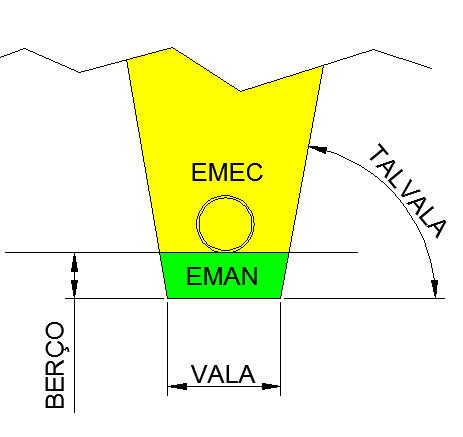
AREACORTE - cut area
Gives rise to the values of mechanical excavation, EMEC, marked in yellow in the drawing below:
-
AREABERCO -
corresponding area part of the cot and gives rise to the values of manual excavation EMAN.
In the image above, the area correspond green .
-
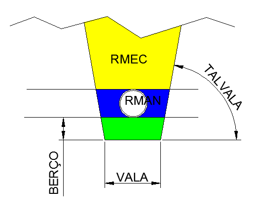
AREAHTUBO -
corresponding area part of the height of the pipe and rise to values
manual refill RMAN manual.
In the image below, the area correspond blue .
The pipe section is discounted.
-
AREATUBO - Area of the outer pipe
-
AREAREATERRO - corresponding Area to mechanic backfill.
Gives rise to the values of the column covering mechanical RMEC.
In the image below, the area correspond yellow .
-
COMPESCORA - Length of anchor.
Corresponds to the sum:
COMPESCORA = LD + LE
In the figure below:

-
DIST - Distance between sections.
Given by:
DIST = EST (i) - EST (i - 1)
-
Location

-
OFFSETESQ - Left offset distance
-
COTAOFFSETESQ - Left offset elevation
-
BORDOESQ - Left edge distance
-
COTABORDOESQ - Left edge elevation
-
OFFSETDIR - Right offset distance
-
COTAOFFSETDIR - Right offset elevation
-
BORDODIR - Right edge distance
-
COTABORDODIR - Right edge elevation
 See also:
 Plan Preview