 Parcel Sheet Creator
The command ParcelSheetCreator allows to generate the sheets with sketches and descriptions of each lot or parcel selected.
To use the command, invoke it and the screen below will open:
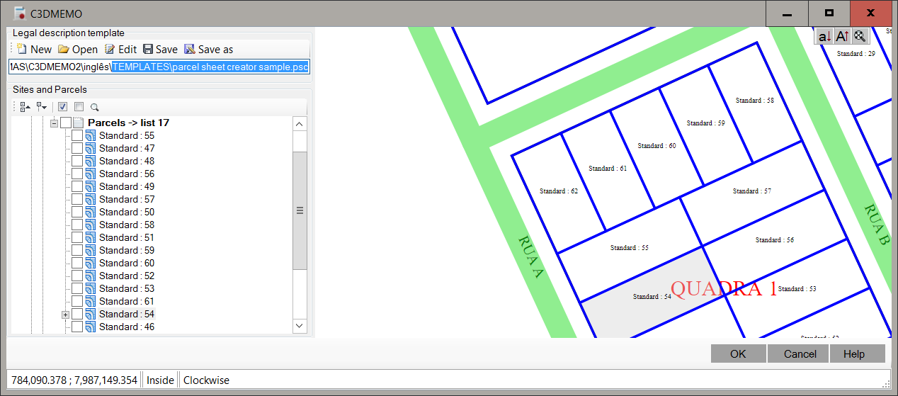
On this screen, on the toolbar, you can:
-
 New clears the screen to create template
-
 Open template file
-
 Save template settings to a file
-
 Save As, saves the template to a different file
Click  Edit button and bellow screen open:
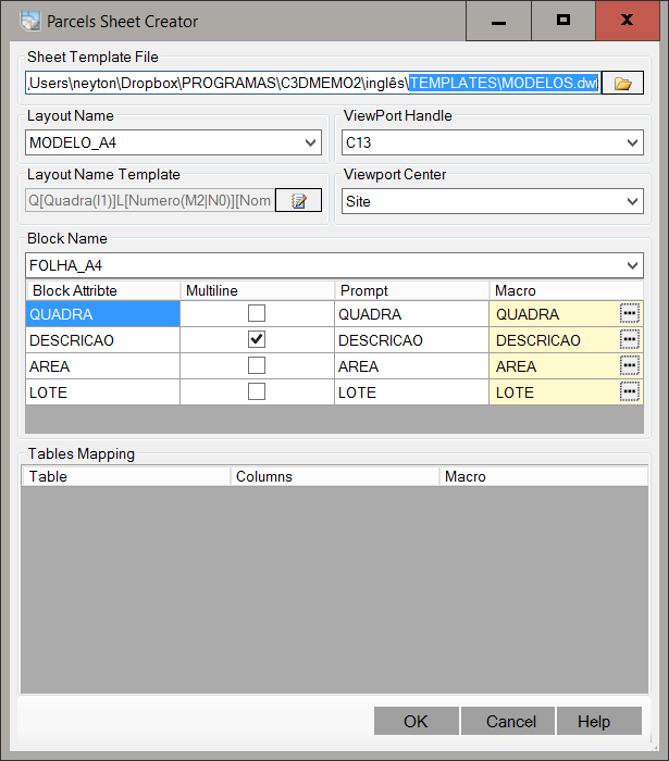
The template file leaves Stores the properties listed below:
-
Template file - Location of the template (*.dwt)
The file must contain at least one layout and this should be at least one block with attributes and a ViewPort.
The example below
illustrates this:

In the program package, has a "*.dwt" file as an example.
The leaf size and configurations is to choose.
-
Layout - tells you what layout template file will be used as a model for the generation of the sheet
-
Block - tells you what block Layout is the stamp or seal of the sheet
-
ViewPort center:
-
ViewPort - tells you what ViewPort will show the lot.
Note: will be made zoom center on the lot, so
set the scale correctly.
-
Layout Name Template - Tells how the layout name will be formed.
Click the button Edit to create a macro
-
Attribute Mapping - Each attribute block may be filled with a lot of information.
If an attribute has the description of the lot and this needs specific formatting or the resulting text is larger than a
line, use attributes of type Multi Line, which are like the MText AutoCAD.
Get help from AutoCAD to see how.
To edit a macro, double click on
 column cell Macro.
Macro Editor will open:
column cell Macro.
Macro Editor will open:

-
Tables Mapping - In some cases, it may want to have a table in AutoCAD layout to describe the vertices with distance and azimuth for example.
ĀĀĀ The block with attributes not help in this case, since the number of table rows is variable.
Thus, one can use this feature.
To do so, enter the same layout template (dwt) where the block,
ĀĀĀ an AutoCAD table (Table command).
Place this table, at least one row with the column headers to facilitate:
|
Vertex
|
X(m)
|
Y(m)
|
Length
|
Azimuth
|
|
|
|
|
|
|
In the Parcel Sheet Creator command, you can use the Macro Editor to edit the columns.
From there, proceed on the issue as Tutorial:

Note that only the macro editor table will be used to fill the AutoCAD table.
If you include that, else, will not be considered.
Finally, on the right screen, choose the Sites and parcels to be processed
and click OK button.
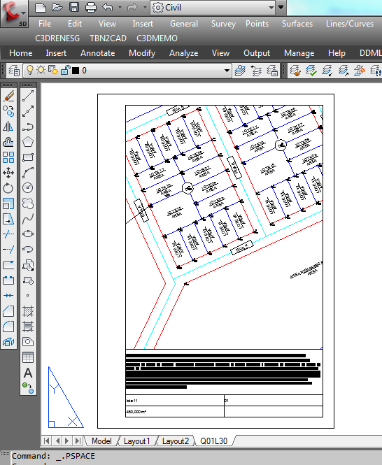
The result will be:
Note: The OK button is available only if a template is defined and
at least one parcel is selected.
After processing the data, are shown in the Error Collector parcels with any problem.